

The European Main Watershed runs across the summits of the Fichtel Mountains, dividing the catchment areas of the Elbe, the Danube and the Rhine. This is where…
The Source of the Eger
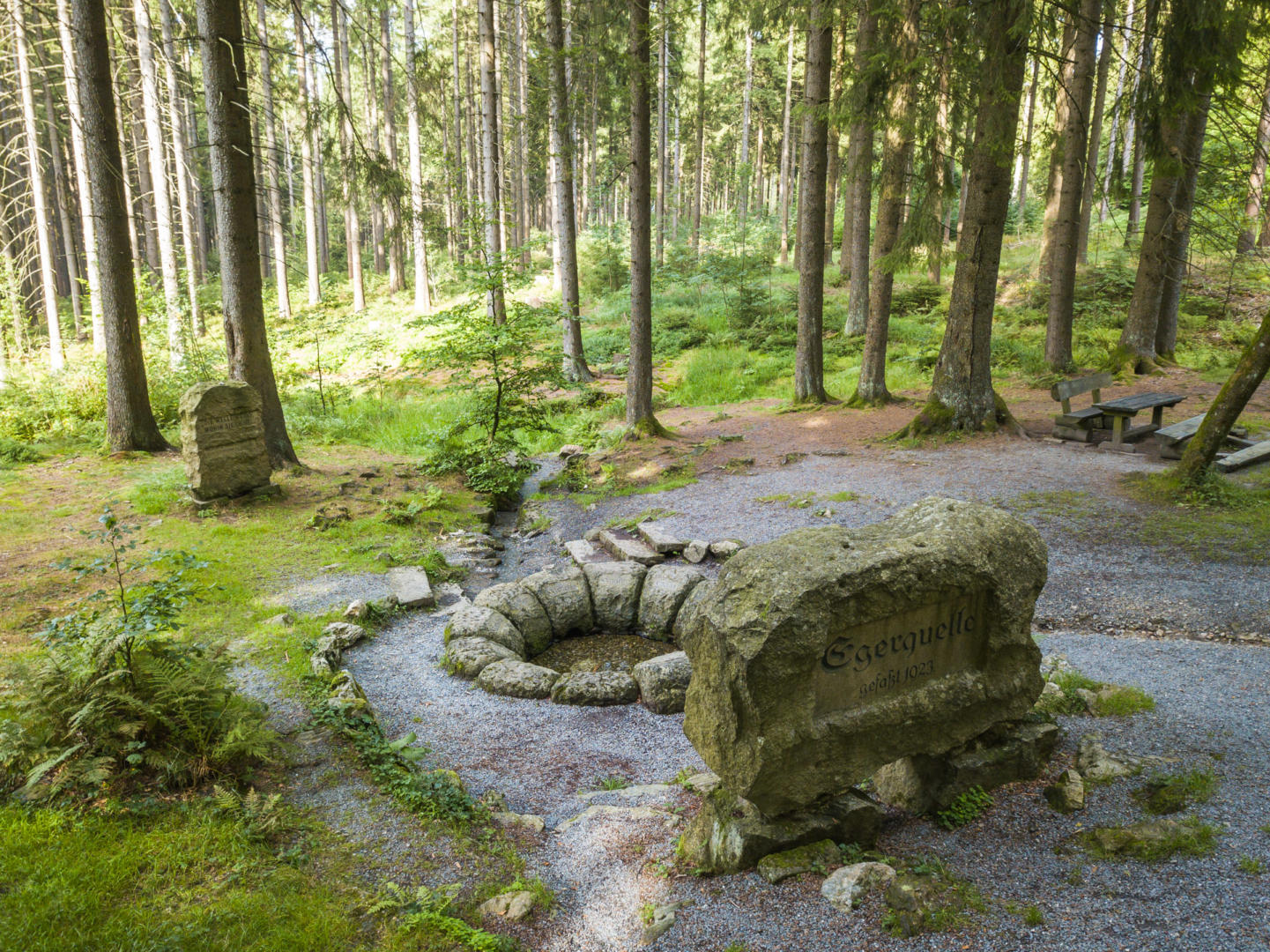


The spring enclosure
The source of the Eger lies on the north-west slope of the Schneeberg, 150 m west of the WUN 1 district road between Weißenstadt and Bischofsgrün. You can reach it on a short footpath from the car park or along the Quellenweg (Springs Trail), one of the main trails of the Fichtelgebirgsverein (FGV). The name “Agara” is said to be of Celtic origin and means something like “nimble, swift”. The first, makeshift enclosure was a simple stone inscribed “Egerquelle 1850”. The present enclosure, dating from 1923, was the initiative of the town of Eger (Cheb). Twelve roughly hewn granite blocks form a ring around the point where the spring emerges. The headstone is slightly larger and bears the word “Eger” together with the coat of arms of the old imperial city. The other stones of the enclosure bear the names of the towns that helped to pay for it: Weißenstadt, Marktleuthen, Königsberg (Kynšperk nad Ohří), Falkenau (Sokolov), Elbogen (Loket), Karlsbad (Karlovy Vary), Fischern (Rybáře), Klösterle (Klášterec nad Ohří), Kaaden (Kadaň), Saaz (Žatec) and Postelberg (Postoloprty). Through the Klösterle block, which forms the outflow, the Eger sets off on its 325 km journey.
The fine stonework was carried out by GRASYMA AG of Wunsiedel, and the official inauguration took place on Whit Sunday 1924. Directly south of the enclosure, a rectangular granite block rests on two stone cubes. Its inscription reads:
When the boy came to the Eger: “Eger, tell me, where are you hurrying?” “To the Elbe,” it rushes more briskly, “to the Elbe I must flow!”
When the boy came to the Elbe, the answer was weighty; thundering back, the river roared: “And I must flow into the German Sea!”Words: Dr Karl Tilp; music: Prof. Josef Freyer. The slightly altered text comes from the song “Podersamer Heimatklänge” (Sounds of Home from Podersam).
A memorial stone of the Sudeten German expellees stands just a few metres from the enclosure and proclaims: “The wave knows where it is going.” The words are by the writer Erwin Guido Kolbenheyer.
The stone was erected by GRASYMA AG of Wunsiedel to mark the Egerlandtag (Egerland Day) held in Bayreuth in 1955. The spring area with its surrounding broadleaved woodland is a protected natural monument. South of the Weißenhaider Mühle mill, on the northern slope of the Schneeberg, lies the source area of the “Alte Eger” (Old Eger). This is said to be the true beginning of the Eger, whose upper course is now called the Zinnbach. For “convenience”, the more easily accessible spring of today was enclosed instead.
Source of the Saale


Source and course
Today it is called the Saxon Saale (Sächsische Saale); in the past it was also known as the Thuringian or Vogtland Saale, to distinguish it from the Franconian Saale, which flows into the Main in Lower Franconia. It rises from an old mine gallery on the north-west slope of the Waldstein in the Münchberg town forest, at 707 m above sea level.
At the Haidberg near Zell it crosses the greenschist zone of the Münchberg gneiss massif. After a short stretch northwards it flows below Weißdorf in a wide arc to the east around the ruins of Uprode. From here it follows the Münchberg–Hof railway line along the sweeping bends of the Saale valley, which turns north again near Schwarzenbach. At Fattigau the Saale is joined by the Lamitz, and at Oberkotzau by the Schwesnitz, which is called the Perlenbach in its upper reaches. South of Hof the upper Regnitz flows into it, and north of the town the lower Regnitz. From Hirschberg to Blankenstein the Saale forms the border with Thuringia. After a total length of 427 km it flows into the Elbe.
History of the Saale source
Compared with the Eger, the Main and the Naab, the Saale drains the smallest part of the Fichtel Mountains. As already mentioned, the Saxon Saale rises from an old mine gallery. Set into the wall of roughly stacked granite blocks is a syenite plaque with the inscription: “Source of the Saale, enclosed by the towns of Münchberg, Schwarzenbach, Hof, Weißenfels, Halle 1869”. The first enclosure was initiated by the town of Münchberg, and the towns named on the plaque shared the costs. The entire site is a protected natural monument.
The source is the starting point of the 427 km Saale Cycle Route.
Since the river was first mentioned, its spelling has changed several times: 791 Sala, 876 Salaha or Saldwa, 965 Salawa or Sala, 1109 Sala and Sale. All these forms contain the root “sal”, meaning “salt”. The ending “-aha” corresponds to “aqua”, i.e. water. The Saale would therefore be the “salt water” or “salt river”. The name probably goes back to the numerous salt springs along its lower course (e.g. Sulza, Kösen, Dürrenberg, Halle).
Source of the White Main

Enclosed with granite blocks, the source of the White Main lies at 887 m above sea level on the eastern slope of the Ochsenkopf, not far from the Weißmainfelsen rock. On foot you can reach it via hiking trails from the Karchesweiher pond or from the summit of the Ochsenkopf.
History of the source
The spring was first enclosed in 1717 by the master huntsman Johann Caspar Munder from Bischofsgrün on behalf of the Margrave of Bayreuth, which is why it was initially called the “Fürstenbrunnen” (Prince’s Fountain). The capstone bears the Hohenzollern coat of arms and the year 1717. The letters “G F C M Z B I P H” around the coat of arms are the initials of “Georg Friedrich Carl, Markgraf zu Bayreuth, in Preußen Herzog” (George Frederick Charles, Margrave of Bayreuth, Duke in Prussia). Of the two numbers, only the right-hand one survives; the left-hand one, as can clearly be seen, was knocked off. The master huntsman’s initials, “J C M”, are carved into the right-hand side of the keystone. The stone to the left of the keystone, bearing the year 1827, recalls the second enclosure of the spring. The polished syenite plaque with the inscription WEISSMAINQUELLE was added after 1886.
Johann Wolfgang von Goethe visited the Fürstenbrunnen with his travelling companions on 1 July 1785. The founders of German Romanticism, the poets Wilhelm Heinrich Wackenroder and Ludwig Tieck, came to the source of the Main on their Whitsun journey on 26 May 1793.
On 6 May 1972 the 542 km Main Trail (Mainwanderweg), Bavaria’s first long-distance hiking trail, was inaugurated at the source. In 1975 the Fichtelgebirge Nature Park restored the spring enclosure at a cost of 23,000 Deutschmarks, channelling four nearby spring outlets into the spring chamber.
The course of the White Main
As far as the foot of the Ochsenkopf, the Main flows steeply north-east to Karches, where it turns sharply north-west and receives its first extra water from small streams coming from the Seelohe moor and from the Schneeberg/Nußhardt. At Fröbershammer it leaves the granite of the central massif. At Glasermühle it turns south-west and flows through a narrow, romantic valley to Röhrenhof and Goldmühl, where it is joined by the Zoppatenbach, a stream that once carried gold. The river then turns north-west again, takes in the Ölschnitz at Bad Berneck, skirts the diabase hills there and moves further and further away from the Fichtel Mountains. Near Steinenhausen (close to Kulmbach) the White Main and the Red Main join to form the Main. After 524 km the Main flows into the Rhine at Mainz.
One of the two starting points of the Main Cycle Route is at the source.
Origin of the name
In antiquity the Main was called “Moenus”, in 794 “Moin”, and in Middle High German “Moun, Moin”; only from the 15th century did the spelling “Main” become established. The name is said to be of Celtic origin, arose along the lower course and means “river”. The epithet “Weißer” (White) appeared in the 17th century to distinguish it from the “Roter Main” (Red Main), supposedly because of the colour of the water. From the 16th to the 19th century the river was used for floating timber from Karches (municipality of Bischofsgrün) to Kulmbach; rafting ponds were created to increase the flow. Its water power drove hammer mills in Fröbershammer, Glasermühle, Röhrenhof and Goldmühl.
Source of the Fichtelnaab
The Fichtelnaab is a headwater of the Naab that rises on the south-east slope of the Ochsenkopf, north-west of Neubau, a district of the municipality of Fichtelberg. The spring on the “Quellenweg” trail, at 867 m above sea level, was enclosed in 1907 by the Fichtelgebirgsverein (Fichtel Mountains Club). From the early 15th to the late 18th century the river was believed to rise from the legendary Fichtelsee lake. In 1787 Pastor Weise of Bischofsgrün noted “that only part of the Nabe flows out of the lake”, and in 1879 the royal senior mining official Dr C. W. Gümbel reported in his “Geognostic Description of the Fichtel Mountains” that the Fichtelnaab rises near the source of the Main on the eastern slope of the Ochsenkopf.
The course of the Fichtelnaab
From its source the Fichtelnaab flows south to Neubau, where it takes in an artificial outflow from the Seelohe moor. It feeds the Mühlweiher pond, flows through Fichtelberg and, south of the village, is joined by the Kratzebach, Schnaitbach and Fuhrbach before continuing south-east through a broad valley. Shortly before Ebnath the Gregnitz flows in, and before Riglasreuth a tall viaduct of the Nuremberg–Marktredwitz railway spans the river. Passing between the basalt of the Armesberg and the granite of the Steinwald, and past the serpentine hills of Grötschenreuth, the Naab reaches the southernmost point of the Fichtel Mountains at Erbendorf. Along the way it is fed by the Höllbach, Felbererbach, Godesbach, Forellenbach and Tiefenbach.
The Fichtelnaab and the Waldnaab merge near Windischeschenbach. Along its entire course, the water power was used commercially to drive hammer mills. As early as 883–887 the river’s name appears on its lower course as “Napa”. On 13 February 1061 a charter records it as “Crumbanaba”; later it was called “Waldnabe” or “Fichtelbergische Waldnabe”, and its present name became established from the early 19th century.
Discover the river sources of the Fichtel Mountains on a hike!
You will find tour ideas in our tour planner.